Press Release from the USDA
 A new USDA study shows that farmers using combinations of erosion-control and nutrient-management practices on cultivated cropland are reducing losses of sediment, nitrogen and phosphorous from farm fields and decreasing the movement of these materials to the Great Lakes and their associated waterways.
“The Great Lakes Conservation Effects Assessment Project (CEAP) study confirms that good conservation planning and implementation have reduced loadings of sediment and nutrients to waterways throughout the region,” Agriculture Secretary Tom Vilsack said today. “The Administration appreciates the actions of every farmer who is stepping up to implement conservation practices, protect vital farmlands and strengthen local economies. At the same time, we also see opportunities for even further progress.”
The CEAP study, prepared by USDA’s Natural Resources Conservation Service (NRCS), estimates that the use of conservation tillage and other conservation practices has resulted in a 50 percent decline in sediment entering rivers and streams, along with 36 and 37 percent declines, respectively, in phosphorus and nitrogen loading.
This latest study, as with CEAP reports on the Upper Mississippi River Basin and the Chesapeake Bay watershed, identifies slightly more than half of cropland as having either a high or moderate need for additional conservation practices to lessen sediment and nutrient losses. The remainder of cropland has low needs for additional conservation – that is, low vulnerabilities to sediment and/or nutrient loss and having adequate conservation management to minimize losses.
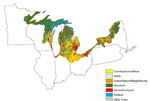
The study covers nearly 174,000 square miles – the entire U.S. side of the Great Lakes Region – including nearly all of Michigan and parts of Illinois, Indiana, Minnesota, New York, Ohio, Pennsylvania and Wisconsin. It is based on data obtained through a survey of farming and conservation practices conducted by USDA’s National Agricultural Statistics Service from 2003 to 2006. More than 1,400 National Resources Inventory sample points provide the statistical basis for estimating conditions throughout the region.
For the CEAP cropland studies, the NRCS works in partnership with USDA’s Agricultural Research Service and Texas AgriLife Research and Extension of Texas A&M University. The interagency modeling team uses computer models to compare simulations of the existing conditions of natural resources in the study area to conditions that would be expected if conservation practices were not in use. The agency expects to have its series of CEAP watershed studies covering the 48 contiguous states online next year.
Read additional information about the Great Lakes Conservation Effects Assessment Project study, including the full report.
Click here for a pdf summary of the report.
The NRCS is part of an 11-agency task force, the Great Lakes Restoration Initiative, which is combating invasive species, protecting watersheds and shorelines from non-point source pollution, and restoring wetlands and other habitat areas.
The Great Lakes are the largest group of freshwater lakes on Earth, holding 95 percent of the United States’ surface fresh water, wide forest and wilderness areas, rich agricultural land, thousands of smaller lakes, and nearly 30,000 islands.


Leave a Reply